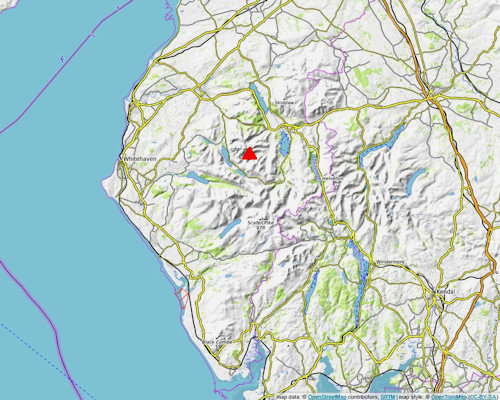
| Knott Rigg - Overview |
 |
|
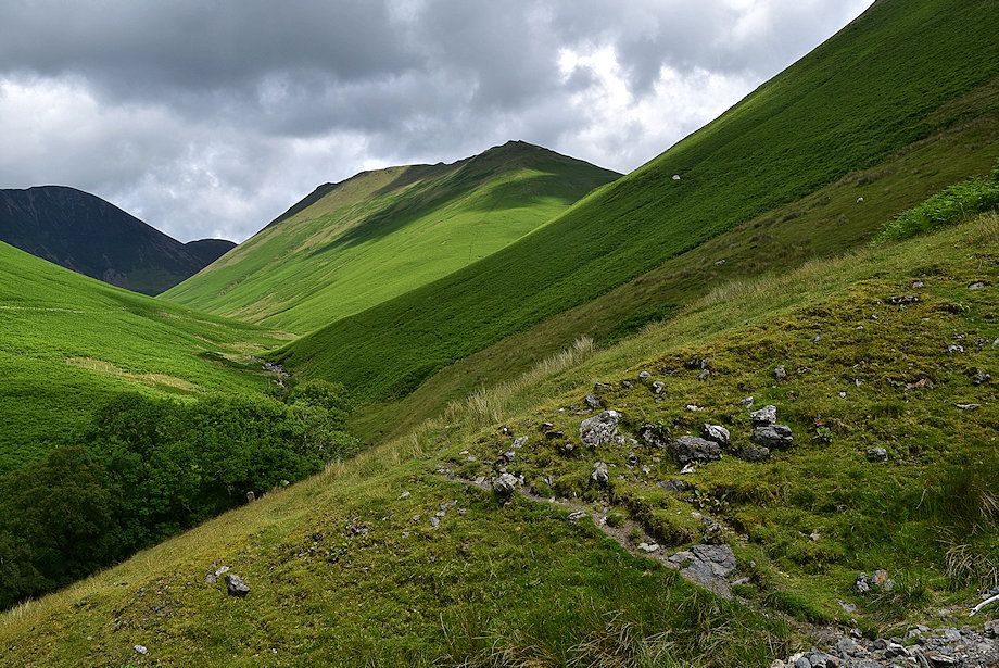 |
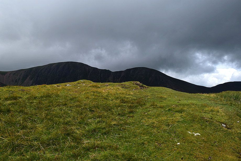
| Knott Rigg from Sail Beck |
|
Knott Rigg together with another Wainwright fell, Ard Crags, form a narrow crescent shaped ridge which lies to the north of the Newlands Valley~Buttermere road. The ridge is defined by Keskadale Beck to its south and the deep troughs of Rigg Beck and Sail Beck to its north. It has a tenuous link with the higher Eel Crag~Causey Pike ridge to the north at a high saddle between the Sail and Rigg becks. Knott Rigg together with its subsidiary top Ill Crag, a Birkett top, occupies the western half of the ridge which terminates at Newlands Hause. Knott Rigg has a subsidiary ridge which falls north east to Keskadale Farm enclosing Ill Gill, a Site of Special Scientific Interest and a Special Area of Conservation. |
| Routes of Ascent |
 |
|
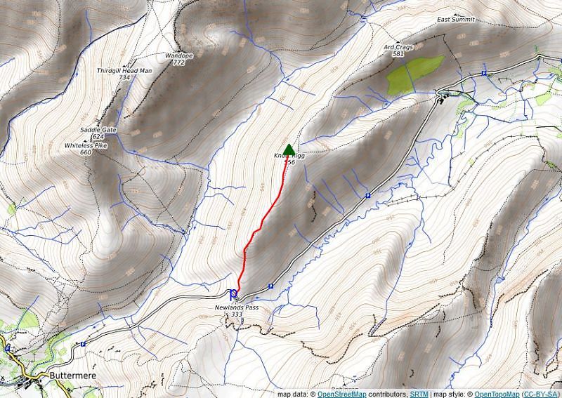
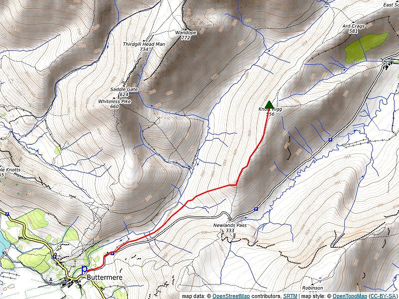
From Newlands Hause |
 |
|
From Buttermere via Sail Beck From the parking area above St.James' church walk up the Newlands Hause road past the reservoir building and a gate in the post and wire fence. Look for a path where the fence begins to descend into the valley of Sail Beck. The path is a sheep trod which falls gently high above Sail Beck towards Swinside Gill at the foot of Knott Rigg's south west ridge. Step over Swinside Gill and continue on a clear path through the bracken which covers the lower slopes of the ill-defined ridge. The path becomes a little less clear as it gains the open grass slopes above the bracken before it eventually emerges onto the south ridge and joins the well used path coming up from Newlands Hause. More details of this route can be found here Distance - 1.9 miles |
 |
|
From Keskadale Farm via Keskadale Edge There are several opportunities to park along the wide grass verge on the un-enclosed road to the south of Keskadale Farm. Walk back along the road towards the farm. Locate a path on the left of the hairpin bend below the farm, cross a fence stile and follow the fence to another stile. A clear path through the bracken climbs across the eastern flank of Knott Rigg, this is an old drove way which provides an easier route than the steep ridge of Keskadale Edge alongside Ill Gill. However the Edge has no difficulties and gives better views both into Ill Gill and the surrounding fells. Leave the drove way path a short distance beyond the stile and follow a path alongside the fence enclosing the Keskadale Oakwood Special Area of Conservation on the right. Continue straight ahead along the ridge when the fence turns away towards the head of Ill Gill. The gradient eases as the path rises over the final heathery knolls on the ridge to reach the open grass slopes below the summit where it becomes indistinct. Climb due west, passing two fenced bogholes to join the path which comes up from Newlands Hause, just a few yards below the summit of Knott Rigg. Distance - 1.25 miles |
| The Summit |
 |
| The summit is unremarkable, consisting of two low grassy mounds of similar height about 30 yards apart. A small untidy cairn occupies the western mound which has been built from stones gathered together from a few exposed areas of the underlying rock. |
| The View |
| Despite its modest height the view from the summit is quite good. Although the nearby Eel Crag ridge severely restricts the view to the west and north, elsewhere the prospect is more open, particulary towards the north-east where Blencathra is prominent across the Newlands Valley. The full length of the Hevellyn range can be seen to the east while to the south west the High Stile ridge is prominent beyond the valley of Sail Beck |
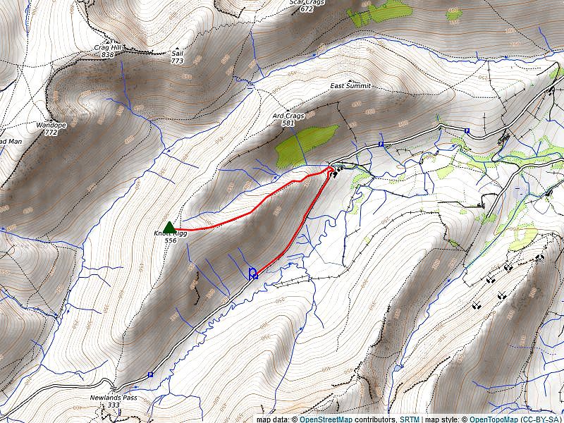
| Ridge Route to Ard Crags |
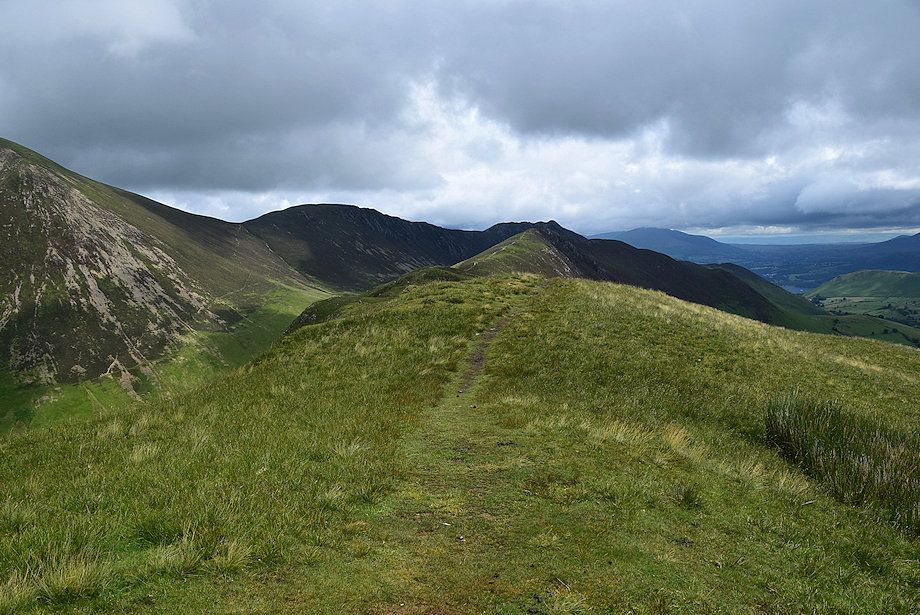 |
| Ard Crags from Knott Rigg (hover over image to view route map) |
|
Continue north-east along the well defined path for a quarter of a mile to reach the rocky summit of Ill Crag, a Birkett top which is not named on the OS maps. From Ill Crag the path descends to a col which is occupied by a small round pool to the left of the path. Continue in the same direction climbing an attractive narrow heather ridge to reach the Wainwright summit of Ard Crags Ditance - 0.85 miles |
|
Safe Descents All the routes of ascent descibed above can be safely used in descent with the proviso that the lower section of Keskadale Edge is very steep, the old drove path which runs parallel with the edge and at a lower level is an easier option. If returning to Buttermere in thick hill fog, the turn off point for the descent into the Sail Beck valley can be easily missed as initially there is no path, in that case it's safer to keep with the clear path to Newlands Hause. |
| Circular walks which include Knott Rigg |
 |
|
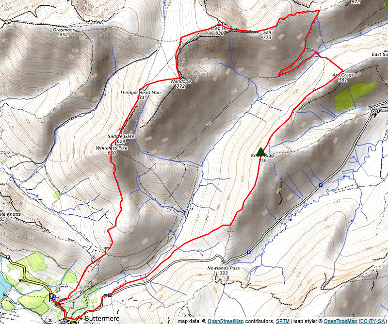
The Sail Beck Round Starting from the National Trust car park in Buttermere walk back along the road towards the village. Opposite the cottages of Crag Houses a signpost indicates the start of a path which leads over the low rise of High House Crag. On passing over the crag a wide green path climbs to a col between Low Bank and Whiteless Breast which overlooks the head of Rannerdale. The ascent continues from the col on a steep path which zig-zags up the facing slope then makes a rising traverse across the western slopes of Whiteless Breast to reach the col under Whiteless Pike and Whiteless Breast. The south ridge of Whiteless Pike steepens as the path approaches the summit, threading its way between rock outcrops, to arrive at the elegant top of Whitless Pike which gives fine views over Buttermere and Crummock Water. Descend north-east to Saddle Gate and climb the narrow ridge of Whiteless Edge, which affords dramatic views down into Third Gill on the right, to a large cairn on Third Gill Head Man. The summit of Wandope lies a third of a mile to the east across the simple grass slope of Wandope Moss. The summit cairn overlooks the hanging valley of Addacomb Hole. Leave Wandope by following the edge of Addacomb Hole as the slope steepens approaching Scar Crag veer left to join a wide path which climbs directly to the extensive summit plateau of Eel Crag. From the Ordance Survey column head south-east to a corner of the plateau and descend the rocky east ridge (The Scar), which is steep and narrow requiring care, to the col under Sail. A good path leads up from the col to Sail's wide summit dome. The path avoids the small cairn marking the summit which lies 25 yards to the left of it beside a small pool which sometimes dries up in summer. Rejoin the path which descends the south-eastern slope of the fell to arrive at Sail Pass. Turn back sharply right at the pass and descend south-west into the valley of Sail Beck on a clear path through the heather. On joining the path which runs between Buttermere and the Newlands Valley at a prominent marker cairn turn left and climb to the high saddle between the valleys of Rigg Beck and Sail Beck. Turn right at the saddle and ascend the steep north-western flank of Ard Crags by a faint path which leads directly to the summit cairn. The summit of Knott Rigg lies 1 mile to the south-west along a delightful heather and grass ridge. The main path avoids the summit cairn wich lies to the right of it as it starts the long descent to Newlands Hause. After descending for a little over half a mile leave the path as it begins to turn slightly to the south and descend an ill-defined subsidiary ridge which leads south-west down into the valley of Sail Beck. Initially there is no trace of a path but a clear one develops amidst the bracken which cover the lower slope. Step over Swinside Gill at the foot of the ridge and follow a clear sheep trod as it climbs gently to join the Newlands Hause road a third of a mile above Buttermere village. Distance - 7.9 miles |
 |
|
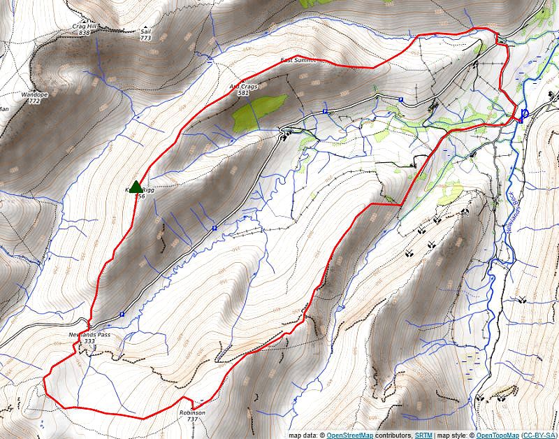
The Keskadale Round Start from the small Chapel Bridge car below Little Town in the Newlands Valley. Cross the bridge and turn onto the lane leading to Newlands Church. Continue on past the church to Low High Snab Bank Farm with fine views of Robinson and Scope End on Hindscarth from the lane. Pass the farm cottage to a gate giving access to a wall and fenced path which runs below the eastern slopes of High Snab Bank into the valley of Scope Beck. Where the wall on the right turns uphill leave the valley path for one which climbs through bracken and gorse onto the High Snab Bank ridge. Continue on along the narrow ridge for almost half a mile to its highest point which overlooks Blea Crags and Robinson's north east ridge. Descend to a narrow col and embark on the climb up the north west ridge almost immediately encountering the first of three rock outcrops on Blea Crags which require care if icy or wet. The first outcrop is easily climbed, the second is much steeper but can be by-passed on the left, the third, more formidable, can be climbed by traversing left on a rock shelf to a shallow scoop leading up to the top of Blea Crags. The ridge broadens and much of the difficulties are over with just one more rock step to negotiate as the path climbs the slope below Robinson Crags. The rock step is easy angled and simple to climb, from its top the path follows the precipitous edge of Robinson Crags to reach a large cairn set on a rock outcrop. The cairn is visible from the valley floor and appears from there to be the summit of Robinson but that lies a third of a mile further along a widening plateau, a line of cairns mark the way in foggy weather. From the summit of Robinson a cairned path descends south-west down to the edge of Buttermere Moss. Cross the wide expanse of the Moss in the direction of High Snockrigg. On reaching drier ground turn half right following a path onto its gentle north west slopes. The path drops more steeply to the left of the crags which enclose the impressive waterfall of Moss Force to arrive at Newlands Hause. A short fingerpost points the way to Ard Crags from the parking area on Newlands Hause. A broad green path sweeps up to a line of rocky outcrops on the skyline from where the summit of Knott Rigg comes into view across a slightly marshy depression. Continue on from the small cairn on Knott Rigg, passing over the subsidiary top of Ill Crag. From the depression beyond Ill Crag an attractive heather-clad ridge leads up to the summit of Ard Crags. Follow the narrow ridge towards Ard Crags' East Top which provides a fine viewpoint of the fells climbed on this circuit of the Keskadale. All that remains is the steep descent over Aikin Knott, as the ridge broadens below Aikin Knott trend half left onto a diagonal path through the bracken to stride over Rigg Beck. Follow the path on the opposite bank back to the road near Rigg Beck Bridge, and return along the lane opposite the bridge to the car park at Chapel Bridge. |
 |
|
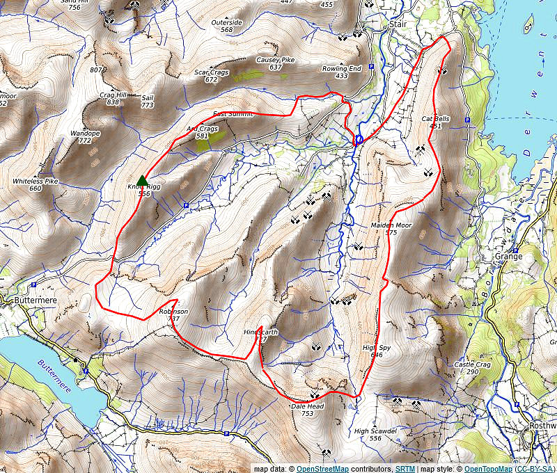
The Greater Newlands Horseshoe Park at Chapel Bridge in the Newlands Valley and take the field path from Little town to Skelgill then the lane from there to the car park above Gutherscale. A path starts from the back of the parking area, rising diagonally to join a partly stone-pitched path which climbs steadily to the crest of Skegill Bank. Follow the gently undulating ridge leading to a final steep rise to the summit of Catbells. The upper section of the ridge requires a little scambling over bare rock to reach the top. Follow the ridge south over Mart Bield to the broad col of Hause Gate which is crossed by an old miner's path between Manesty and Little Town. Continue straight ahead from the col on a well used path which curves above Yewthwaite Combe. This main path by-passes the actual summit of Maiden Moor and, higher up, has inferior views, so when the slope eases as the path approaches the summit ridge trend right onto a lesser used path that leads up to a cairn above Maiden Moor's north-west ridge which is a wonderful viewpoint. Continue on along the escarpment, passing the head of Barnes Gill and Bull Crag to reach a small pile of stones which mark the summit of Maiden Moor. The path leads on above the edge of the steep slopes falling down to Newlands Beck on the right to rejoin the main path as it passes along Narrow Moor without gaining much height. As it begins to rise more steeply it's well worthwhile to make a short diversion to visit the cairn on Blea Crag on the left for its magnificent view of Derwent Water. Rejoin the main path as it contnues along the escarpment of Eel Crag climbing genty to the tall cairn on the summit of High Spy. Dalehead Tarn, the next objective, comes into view a few yards beyond the summit cairn. A cairned path leads down to it, passing above Miner's Crag to ford the tarn's outlet stream. Pass to the right of the tarn and embark on the 800ft. climb to the summit of Dale Head. The very steep ascent has been made easier by the construction of a stone-pitched path which leads up to an edge overlooking the northern crags, from where easier walking over grass and shale leads up to the impressive summit cairn set on the edge of the crags overlooking the Newlands Valley. The route continues westward descending to Hindscarth Edge, passing three rocky knolls on the way. Easy slopes lead up towards Hindscarth's summit ridge. Look for a shale path which branches off to the right, this provides a 'short-cut' to the summit cairn. Retrace the path south along the ridge to a junction of paths and bear right onto a path which leads down to Littledale Edge. Traverse the narrow edge which gives good views down into Little Dale on the right and Gatesgarthdale on the left. A steady climb leads up to the summit ridge of Robinson passing above Robinson Crag and Hackney Holes to a large cairn set on the southern end of the ridge. Turn north and follow a cairned path on a gentle climb to reach the two low outcrops of rock which mark the summit of Robinson. Descend south-west on a cairned path down to the edge of Buttermere Moss. Cross the wide expanse of the Moss in the direction of High Snockrigg. On reaching drier ground turn half right following a path onto its gentle north west slopes. The path drops more steeply to the left of the crags which enclose the impressive waterfall of Moss Force to arrive at Newlands Hause. A short fingerpost points the way to Ard Crags from the parking area on Newlands Hause. A broad green path sweeps up to a line of rocky outcrops on the skyline from where the summit of Knott Rigg comes into view across a slightly marshy depression. Continue on from the small cairn on Knott Rigg, passing over the subsidiary top of Ill Crag. From the depression beyond Ill Crag an attractive heather-clad ridge leads up to the summit of Ard Crags. Follow the narrow ridge towards Ard Crags' East Top which provides a fine viewpoint of the fells climbed on this circuit of the Newlands Valley. All that remains is the steep descent over Aikin Knott, as the ridge broadens below Aikin Knott trend half left onto a diagonal path through the bracken to stride over Rigg Beck. Follow the path on the opposite bank back to the road near Rigg Beck Bridge, and return along the lane opposite the bridge to the car park at Chapel Bridge Distance - 14.25 miles |
|