| Bowscale Fell - Overview |
 |
|
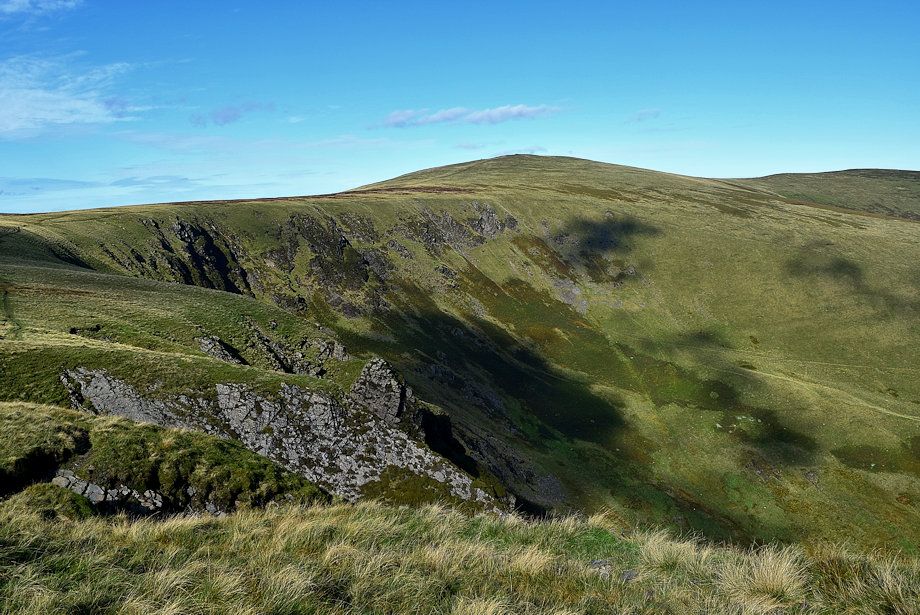 |
| Bowscale Fell across the headwall of Bannerdale |
| Bowscale Fell in the Northern Fells is the highest and most dominant of a compact group of three fells which stand to the north and east of Blencathra within the water catchment area of the River Caldew and the River Glenderamackin. |
| Routes of Ascent |
 |
|
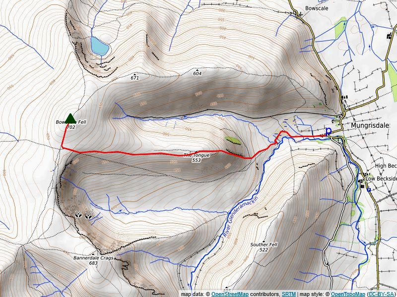
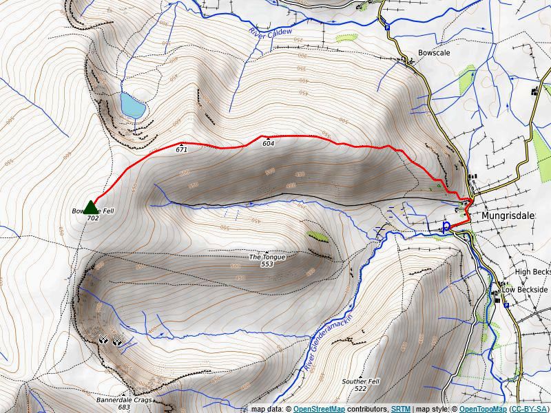
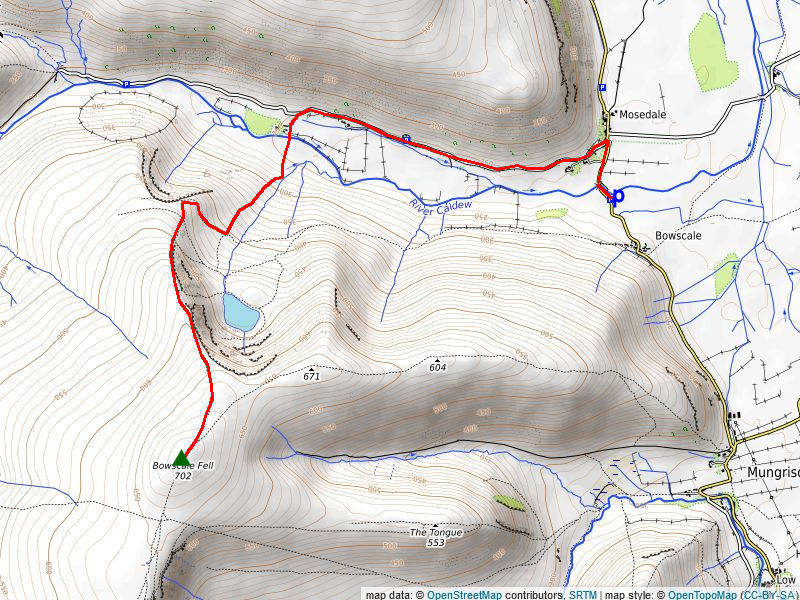
From Mungrisdale via Bannerdale (1) The path divides above the footbridge, the left branch continues alongside the River Glenderamackin, the way forwards lies straight ahead up a bracken-covered steep bank, at the top of the bank the path splits, keep to the right which is much clearer, both paths re-unite higher on the slope. As the path gradually climbs around the south-eastern slopes of The Tongue Bannerdale Crag's impressive east ridge comes into view, and as it levels off and enters Bannerdale itself the great cirque of crags which form the valley's headwall loom ahead. The path now makes a rising traverse across the bracken covered southern flank of The Tongue towards the right side of the headwall's crags , halfway along the traverse a marker cairn indicates the point where the path forks, keep right on the rising path through the bracken, the left branch eventually fades away in the floor of the valley below the steep headwall. The bracken eventually gives way to grass on the approach to the ridge between Bannerdale Crags and Bowscale Fell. Just below the ridge the path splits again, the left, clearer, branch continues along the top of the headwall towards Bannerdale Crags, keep straight ahead on a fainter path which climbs up a steep bank to meet a single upright slate stone on the ridge which stands at a 'crossroad' of paths. Turn right from the stone, onto an excellent path, the summit of Bowscale Fell lies a little under a quarter of a mile from the marker stone and 150 feet higher. More details of this route can be found HERE Distance - 2.3 miles |
 |
|
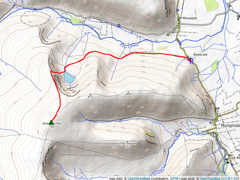
From Bowscale via Bowscale Tarn (2) Start from the hamlet of Bowscale where there is informal parking available on the wide verge. A rough lane opposite the acute bend between the houses passes a row of cottages and leads on to a gated bridleway track. The bridleway, leading to Bowscale Tarn, was once popular with early aesthetic visitors to the Lake District during the Picturesque Movement in the late 18th century who were carried up by ponies to view the tarn through their Claude Glasses. The tarn, according to an ancient legend is occupied by two immortal fish who can speak and tell fortunes. William Wordsworth alluded to the lengendary fish and their powers in his poem of 1807 'Song at the feast of Brougham Castle' which had the effect of greatly increasing the traffic to Bowscale Tarn, much to the delight of local guides with their ponies. The broad bridleway track runs alongside an intake wall high above The River Caldew without gaining much height for just over half a mile before rising a little more steeply to ford Drycomb Beck from where it curves around Slatestone Rigg, a subsiduary spur of Bowscale Fell's long east ridge. Tarn Crags comes into view on rounding Slatesone Rigg as the bridleway turns south-west and begins to climb across the bank of the large moraine below the tarn to reach Tarn Syke, the tarns outlet stream, follow the stream for 80 yards and the tarn suddenly comes into view, presenting a magnificent sight backed by the tiered wall of crags along the headwall of the combe. Step across the stream just below the point where it issues from the tarn. A thin but clear path climbs towards an obvious wide grassy rake which cuts through the grags on the western side of the combe. The path is very steep and worn as it nears the line of Bowscale Fell's north ridge and gives dramatic views down to the tarn and the crags immediately to the left. On reaching the ridge line the path continues to climb alongside the the escarpment of the combe, for just over a quarter of a mile before it swings slightly to the south-west and joins the east ridge path, 50 yards below the large north cairn on the summit ridge. More details of this route can found HERE Distance -2.5 miles |
 |
|
From Mungrisdale via The Tongue (3) The steep prow of The Tongue throws down a challenge to walkers as they set out from Mungrisdale along the River Glenderamackin. Follow the course of Route One to the footbridge crossing Bullfell Beck and take the ensuing upper path as far as an old sheepfold where a path breaks off to the right and begins to climb the steep nose of The Tongue, in summer its start may be difficult to trace in the tall bracken on the lower slope. The bracken soon diminishes and gives way to grass and heather as the path follows the edge of a graggy escarpment above a shallow combe on the right. After climb of over 600ft the steep angle of the slope begins to ease as the path emerges onto the summit ridge where it splits, the left branch continues on below the crest of the ridge but it is worthwhile to carry on straight ahead to visit the slate cairn on the summit which is a Birkett top. The path carries on from the cairn towards a saddle on the ridge but is soon lost amidst extensive peat hags, so divert left a short distance past the cairn and drop down to join the afore-mentioned lower path below the crest of ridge. This path rises easily for just over three quarters of a mile to join the Route One path as it begins to emerge onto the connecting ridge between Bowscale Fell and Bannerdale Crags. When the upright slate stone comes into view bear half right to join the main ridge path up to the summit of Bowscale Fell. Distance - 2.2 miles |
 |
|
From Mungisdale via the east ridge (4) Park on the short lane by the telephone box and walk along the road towards the hamlet of Bowscale, passing St Mungo's Church on the way. Almost opposite the junction with the minor road to Hutton Roof a gate gives access to a rough track. The usual route leaves the track immediately beyond the gate the track and crosses a pasture field to the left of a small disused quarry and follows a distinct path towards the southern flank of Raven Crags at the end of Bowscale Fell's east ridge. The path leading up to the ridge-line is unpleasant, being very steep and loose, as it zig-zags through thickets of gorse bushes, it can be avoided altogether by continuing with the track for about 500 yards and use a clear path which runs parallel with the usual route. The usual path reaches a fairly level shoulder above Raven Crags and continues in the same direction along the broadening ridge and begins to climb over two distinct, but unnamed tops, on the way to the summit of Bowscale Fell. The gradient eases slightly as a cairn on the first unnamed top comes into view on the skyline. The cairn does not mark the actual summit of the first unnamed top which lies a further quarter of a mile along the ridge but on reaching it the second unnamed top comes into view straight ahead with the summit of Bowscale Fell appearing to its left. On passing to the right of the summit of the first unnamed top, which has no cairn, the path dips slightly to a col before resuming its steepish climb towards a prominent cairn on the second top which, although unnamed on the OS map, is commonly referred to as Bowscale Fell East Top by fellwalkers. The flat summit of the East Top lies a further 170 yards from the prominent cairn and is marked by two flattish cairns which are 50 yards apart on an east-west axis. From the western cairn the path swings to the south-west as it descends to a narrow col which overlooks Bowscale Tarn, the tarn is best viewed by walking a few yards north-west from the path. The north cairn on Bowscale Fell's summit ridge is clearly in view on the skyline from the col and only requires a simple climb of around 170 feet over a third of a mile to reach it. The large summit cairn/windshelter lies a further 100 yards along the almost level ridge. More details of this route can be found HERE Distance - 2.4 miles |
 |
|
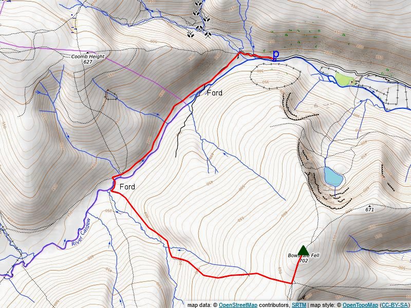
From Mosedale via Blackhazel Beck (5) This is an unfrequented route and although the path is marked on the OS map as a PROW it is very obscure in places, also it requires fording the River Caldew which, if it is in spate, can be quite hazardous. Park on the wide verge near the end of the public road in Mosedale. Walk up the road and cross Grainsgill Bridge to join the Cumbia Way track which follows the course of the River Caldew, on passing a locked barrier above the lower ford, Skiddaw Little Man begins to dominate the head of the valley. The wide track comes to an end as it meets Wet Swine Gill, a rough path continues on below Cocklakes and crosses Burdell Gill which is just over a mile from Grainsgill Bridge. Shortly after passing the gill look for a suitable crossing point over the Caldew near the confluence with Blackhazel Beck, in dry conditions it is normally at its narrowest where it flows in two channels, in any case whichever crossing point is chosen it probably requires 'boots off' wading so walking poles will come in handy. Once across the river the route keeps well to the north of Blackhazel Beck, initally over a stretch of a wet area before reaching drier ground and passing by some ruined sheepfolds and huts. Where Blackhazel Beck begins to turn to the south step over a mnor tributary stream, continue in the same direction to pass another ruin on the left before turning to the east and following the course of the stream to its source, beyond which, the path becomes more evident as nears the line of ridge between Bowscale Fell and Bannerdale Crags before arriving at the single upright slate stone which marks a 'crossroad' of paths. Turn left from the stone on the clear path which leads easily up to the windshelter on the summit. Distance - 3.3 miles |
 |
|
From Mosedale via the north ridge (6) Park in a lay-by below the old bridge over the River Caldew and walk up the road for 400 yards to the hamlet of Mosedale. Take the mnior road on the left which is signposted for Swineside. Pass the Friends Meeting House and Brant Farm on the left and follow the pleasant road above the River Caldew with fine views ahead of Coomb Height which appears to close off the head of the valley, and of Tarn Crags on Bowscale Fell's north ridge. When the bracken is low the ascent path to Bowscale Tarn and the north ridge may be seen climbing out of the valley onto the slope below the tarn. After walking along the road for almost a mile pass Swineside Farm and shortly after that turn off the road at Roundhouse and descend to cross a footbridge spanning the Caldew. The path on the other side of the ridge rises to come alongside Tarn Syke then breaks away right from it and climbs a bracken-covered rigg heading for the Bowscale Tarn combe. Once clear of bracken it encounters a path traversing across the slope which is about 750 yards from the footbridge, turn right and follow that path which becomes broader as it climbs up to the north ridge well to the right of Tarn Crags. The path is most likely used as a drove-way to bring sheep down to the valley to avoid the crags. The path crosses over the ridge above a small combe, leave it as it reaches its highest point, turning left to ascend the north ridge. There is no path at first but one develops as the escarpment of Tarn Crags draws near. Follow the escarpment, which allows very good views down to Bowscale Tarn, for half a mile, as the path passes the head of the combe on the left, it turns slightly to the south-west and climbs the gentle slope to quickly arrive at the north cairn on the summit ridge. Distance - 3.1 miles |
 |
|
From Mungrisdale via Bullfell Beck (7) This is the certainly the most direct route to the summit which makes use of the excellent track that serves the waterworks building in the deep trench of the Bullfell Beck valley. The access gate to the track is located almost opposite the junction with the minor road to Hutton Roof as detailed in Route 4. The track climbs gently for about a mile to end at the small building from where a plain footpath continues up the narrowing valley which is hemmed in by the slopes of The Tongue on the left and Bowscale Fell's east ridge on the right. High on the slope of the east ridge is the oddly named Young Wood, a ribbon of ancient oak woodland, within the Skiddaw Group SSSI, it is regarded as the highest Atlantic oakwood in England, the wood has been fenced off to exclude sheep and encourage its successful re-generation. After passing above a ruined sheepfold the path draws nearer to Bullfell Beck, which has some attractive cascades in view from the narrow path as it rises more steeply through heather to where the beck forks. The path crosses the right fork and begins to rise up a very steep heathery tongue between the two headwaters, it is soon lost in the heather, carry on straight up and, as the heather relents, aim half left on the grassy slope to head directly for the summit cairn/windshelter. |
| The Summit |
 |
| The summit is a mainly grassy slightly elongated dome on a south-west/north-west axis. A large cairn which has been hollowed out to form an ineffectual windshelter occupies the highest point, a more shapely cairn lies almost a hundred yards to the north-east is at a similar elevation. |
| The View |
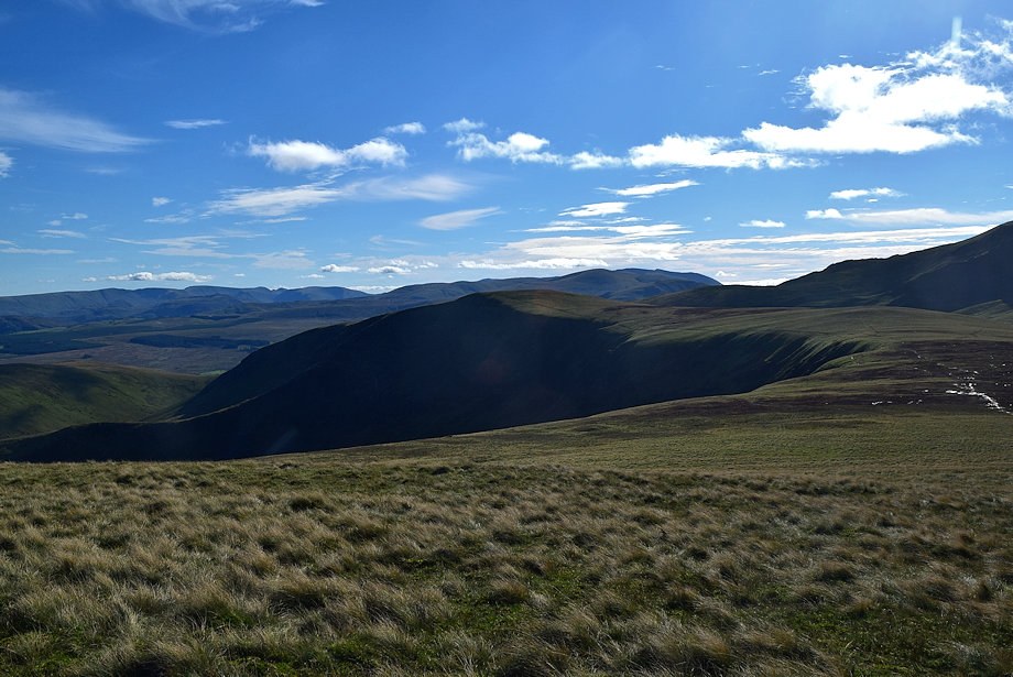
| The view from the summit is very extensive. Looking east and south-east, a long line of the distance Pennines are on the horizon while the Sottish hills are visible across the Solway Firth to the north-west Closer at hand the Helvellyn range is seen end on above the summit of Bannerdale Crags. South-west, the highest peaks of the Western and North-Western Fells make an appearence to the left of Skiddaw but mostly the eye is drawn to Blencathra where Atkinson Pike and Foule Crag tower above Sharp Edge. |
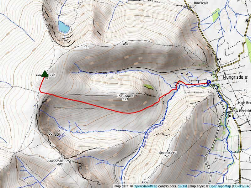
| Ridge Route to Bannerdale Crags |
 |
| The connecting ridge to Bannerdale Crags (Hover over image to view map) |
|
The broad ridge which connects to Bannerdale Crags has a large area of marshy ground around its lowest point which is best avoided by following the escarpment above the headwall of Bannerdale. Head south-southwest from the windshelter on a clear path which drops down meet a single upright slate stone which stands on a 'crossroad' of paths, the onward path splits at this point, keep left on a path which begins to angle towards the escarpment to join a track which curves around Bannerdale's craggy headwall. A simple climb ensues of around 170 feet leads up to a large cairn which sits on the very brink of the crags, the summit of Bannerdale Crags lies almost a hundred yards to the south-west and is marked by a meagre pile of stones. Distance - 1 mile |
|
Safe Descents The safest descent route in poor visibilty is by the east ridge, bear half right from the north-east cairn on a clear path. In an emergency, the Bullfell Beck route is the quickest way down, although initially it is very steep and pathless, aim a few degrees south of west from the north west cairn to locate the headwaters of the beck. |
| Circular walks which include Bowscale Fell |
 |
|
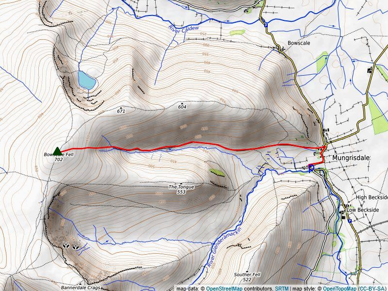
Around The Tongue Start from the short lane near the telephone box in the village where there is room to park for about six cars, a collection box on the right requests a parking fee. If these spaces are full there is more parking available on the wide verge beside the River Glenderamackin and opposite the village hall. Walk past the cottages to a gate at the end of the lane which gives access to a rough track that runs alongside the River Glenderamackin wth The Tongue, a subsiduary ridge of Bowscale Fell, dominating the view ahead with Bannerdale Crags' east ridge beyond it on the left. A section of this long established track was washed away, together with the footbridge over Bullfell Beck, during a catastrophic storm in 2015, a stubby footpath sign directs walkers onto a new path away from the river. This new inverted soil path loops around very wet rushy ground, and as it turns towards Bullfell Beck, large thick slate flagstones have been laid across the swamp but they are slowly sinking into it. The path does reach drier ground as it descends and crosses Bullfell Beck via a new footbridge. Carry on straight ahead from the footbridge to come once more alongside the River Glenderamackin, Initially the path traverses above a steep landslip as it climbs above the river where a little care is required but it soon improves. On rounding a corner Bannerdale Crag's east ridge comes into view, unfortunately there is a stretch of wet and boggy ground to negotiate as the path descends to cross Bannerdale Beck via stepping stones. On crossing the beck leave the main path to begin the ascent of Bannerdale Cragg' east ridge, the path steps up a steep bank and aims for a rocky outcrop which can be see on the skyline. Continue in the same direction descending a steep but short slope and follow the path around the great cirque of crags above the headwall of Bannerdale without gaining or losing much height. As the craggy escarpment begins to turn to the north-east divert left onto a path (spongy in places) to eventually meet a single upright slate stone which marks a 'crossroad' of paths, continue straight ahead from the stone up the easy angled slope for almost a quarter of a mile to the summit cairn/wallshelter on Bowscale Fell. Walk along the short summit ridge towards the large northern cairn and descend in a north-easterly direction for 50 yards to a junction of paths, take the right fork which drops down to a saddle above the Bowscale Tarn combe. The tarn cannot be seen from the path on the saddle but comes into view by diverting from it 50 yards to the north. The continuing path rises gently from the saddle to the summit of Bowscale Fell East Top which is marked by two cairns. From the East Top continue along the east ridge to a second, unnamed top, before gradually dropping down towards the end of ridge above Raven Crag. The path swings to the south and descends steeply through a thicket of gorse bushes to a pasture field, cross the field and join a rough track, a gate on the left leads onto the main road opposite its juntion with the minor road to Hutton Roof. Follow the main road back towards Mungrisdale for a quarter of a mile to complete the circuit. Distance - 5.6 miles |
 |
|
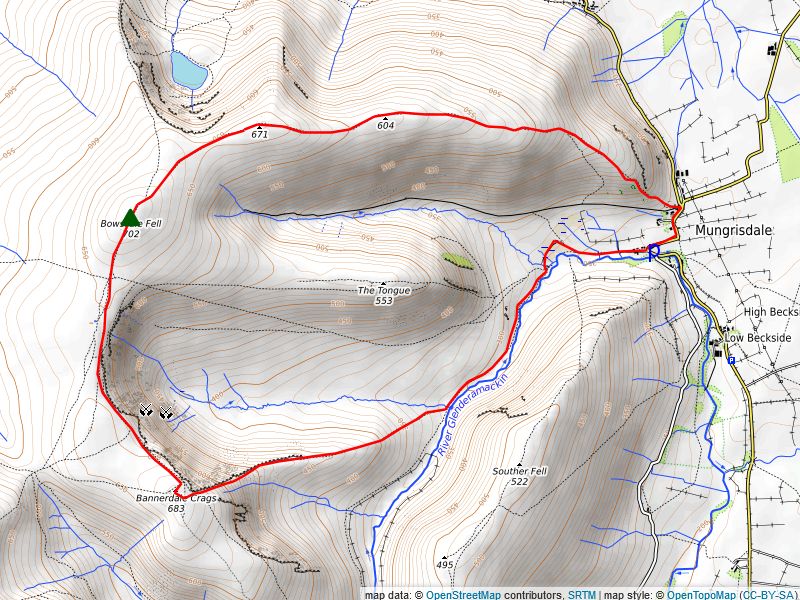
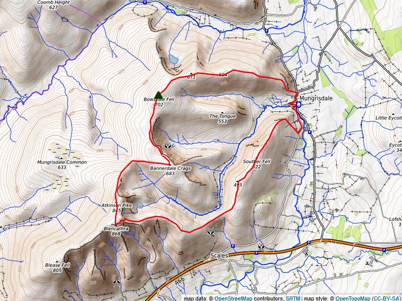
The Glenderamackin Round Park opposite the community hall (donation towards upkeep of the hall requested) or for free on the wide verge beside the River Glenderamackin as you enter the village. Cross the footbridge over the river opposite the hall and walk along the minor road which runs between Mungrisdale and Scales for a little over a third of a mile, the road rises to a gate which gives access to the open fellside. Turn acutely right and follow a path which makes a rising traverse across the bracken-covered hillside above the intake wall to gain the line of the north-east ridge which overlooks Mungisdale. A green path works its way around rock outcrops which are a feature on the lower part of the ridge's steep prow, gradually the slope eases as the summit of Souther Fell comes into view, the highest point is marked by an embedded rock which sometimes is adorned with a few stones. Continue along the broad ridge for almost 300 yards to a shallow col, the path splits here, take the right fork which rises over a mnor top then veers down to a well built cairn which offers a great viewpoint across the Glenderamackin valley to Blencathra and Bannerdale Crags. Turn south from the viewpoint cain to rejoin the main path as it drops down to the col above Mousethwaite Combe. Continue in the same direction, ignoring any paths which break off to the left or right, keeping to a clear path which climbs over Scale Fell's eastern slope to join the regular path, which rises from Scales Green, just as it curves around the valley of Scaley Beck. A short diversion left leads up to Doddick Fell Top, which is a fine viewpoint before resuming the climb around the head of Doddick Gill to rise more steepy via zig-zags to gain the summit ridge, Hallsfell Top, the summit of Blencarthra lies 150 yards to the south-west. Head north from Hallsfell Top past a small tarn and a large white cross of quartzite rocks laid out on the ground to a large cairn marking the top of Atkinson Pike. The path continues to the top of the Foule Crag combe and follows its edge, initially over a bank of slate scree, dropping over 700 feet to the Glenderamackin col. Cross the col and keep right where the path splits twice a short distance above the col, the ensuing path fades a little as it approaches the summit of Bannerdale Crags where an untidy heap of slates mark the highest point, a more shapely cairn lies a futher hundred yards to the north-east on the brink of the crags overlooking Bannerdale is a superior viewpoint. The path to Bowscale Fell descends a steep but short slope and follows the great cirque of crags above the headwall of Bannerdale without gaining or losing much height. As the craggy escarpment begins to turn to the north-east divert left onto a path (spongy in places) to eventually meet a single upright slate stone which marks a 'crossroad' of paths, continue straight ahead from the stone up the easy angled slope for almost a quarter of a mile to the summit cairn/wallshelter on Bowscale Fell. Walk along Bowscale Fell's short summit ridge towards the large northern cairn and descend in a north-easterly direction for 50 yards to a junction of paths, take the right fork which drops down to a saddle above the Bowscale Tarn combe. The tarn cannot be seen from the path on the saddle but comes into view by diverting from it 50 yards to the north. The continuing path rises gently from the saddle to the summit of Bowscale Fell East Top which is marked by two cairns. From the East Top continue along the east ridge to a second, unnamed top, before gradually dropping down towards the end of ridge above Raven Crag. The path swings to the south and descends steeply through a thicket of prickly gorse bushes to a pasture field, cross the field and join a rough track, a gate on the left leads onto the main road opposite its juntion with the minor road to Hutton Roof. Follow the main road back towards Mungrisdale for a little under half a mile to the start of the walk. Distance - 9.2 miles |
|