| Ard Crags - Overview |
 |
|
 |
| Ard Crags from Causey Pike's east ridge |
| Ard Crags together with another Wainwright fell, Knott Rigg form a narrow crescent shaped ridge which lies to the north of the Newlands Valley~Buttermere road. The ridge is defined by Keskadale Beck to its south and the deep troughs of Sail Beck and Rigg Beck to its north. It has a tenuous link with the much higher Wandope~Causey Pike ridge to the north at a saddle between the Sail and Rigg becks. Ard Crags occupies the eastern half of the ridge which is firmly rooted in the Newlands Valley at Birk Rigg. The fell assumes a steep-sided conical shape when seen from some parts of the valley floor with a steep ridge rising to the East Top. The northern slopes of the East Top are extremely steep being a mixture of heather and rocks between fans of scree. The southen slope immediately below the summit has a broad sweep of minor crags which give the fell its name, these are divided by the narrow gully of Ard Gill. Below the crags are the Keskadale Oaks, a woodland of mainly Sessile Oaks with some Rowan. Although there is some evidence that the trees have been coppiced for industrial use in the past they are thought to be one of the few remaining examples of the native woodland which once covered much of the Lake District fells. The woodland is now designated as a Special Area of Consevation. Almost all of the southern upper slopes of Ard Crags are covered by heather which flowers in late summer making this the most rewarding time of the year to climb the fell. |
| Routes of Ascent |
 |
|
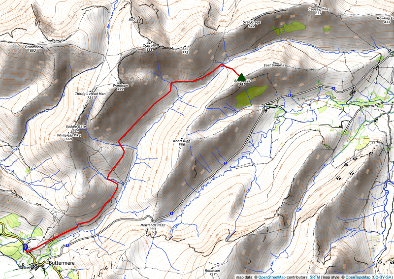
From Buttemere via Sail Beck |
 |
|
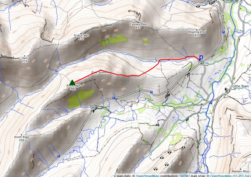
From Rigg Beck Bridge via Aikin Knott Start from a small quarry beside the road bridge over Rigg Beck where there is room to park a few cars. A good path leads along the north bank of Rigg Beck between the slopes of Birk Rigg on the left and Birkrigg Brow on the right. The east ridge of Ard Crags soon comes into view with Aikin Knott and the East Top being prominent. Cross Rigg Beck beyond the wall enclosing the pastures of Birk Rigg and climb the gently rising slope on a diagonal path to the broad ridge below Aikin Knott. The ridge narrows on the approach to Aikin Knott and the path climbs its steep prow through the heather to reach its summit. Pass over another minor bump on the ridge on the way to the East Top which is a fine viewpoint. The summit of Ard Crags lies a further third of a mile along a gently rising narrow ridge. Length - 1.6 miles |
 |
|
From Rigg Beck Bridge via Rigg Beck Start, as Route 2, from the small car park beside the road bridge over Rigg Beck. The path from the car park is the start of a five mile walkers route connecting the Newlands Valley with Buttermere via the valleys of Rigg Beck and Sail Beck. On passing an old sheepfold which will be noticed on the other side of Rigg Beck, the valley narrows as it turns slightly to the south between the impending slopes of Rigg Screes on the left and Scar Crags on the right. Note the small copse high on the heather slope between Scar Crags and Causey Pike, similar to the one on the southern sopes of Ard Crags, it is a relic of the ancient forest of Sessile Oak, Birch, and Rowan which once covered much of the Lake District fells. Arriving at saddle at the head of the valley between Ard Crags and Sail, turn off the path to join Route 1 by crossing slightly marshy ground to the foot of the steep grassy northern flank of Ard Crags. A faint path leads up to the summit ridge ending exactly at the summit cairn Distance - 2 miles |
 |
|
From Newlands Hause via Knott Rigg Ard Crags is usually climbed as an out and back route from Newlands Hause, the highest point of the Newlands Valley~Buttermere road at 1,093 feet, taking in the Wainwright summit of Knott Rigg on the way. There is room to park about 20 cars on either side of the un-enclosed road at the summit of the pass. From a signpost a broad green path sweeps up towards the summit ridge, the path steepens as it approaches a series of rock outcrops. These appear to be the summit of Knott Rigg when seen from the parking area on the hause but that lies a further half a mile along the ridge across a slightly marshy depression. The main path avoids the actual summit of Knott Rigg, where it splits keep left to visit the cairn which is a good viewpoint. Continue on from the summit of Knott Rigg, crossing over another cairned top (Ill Crag), before descending to yet another depression from where a climb of 230 feet along a well defined heather ridge leads up to the summit of Ard Crags Distance - 1.75 miles |
| The Summit |
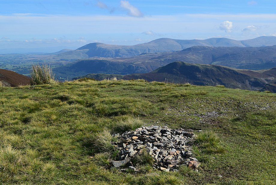 |
| The summit is a gentle dome of grass and patches of heather on the edge of an escarpment of crags high above Keskadale. Small stones from the underlying rock which is evident in places have been gathered together to form a flattened cairn. The tidy cairn of larger rocks which Wainwright featured in his Ard Crags chapter of the Pictorial Guide to the North Western Fells has long since disappeared. |
| The View |
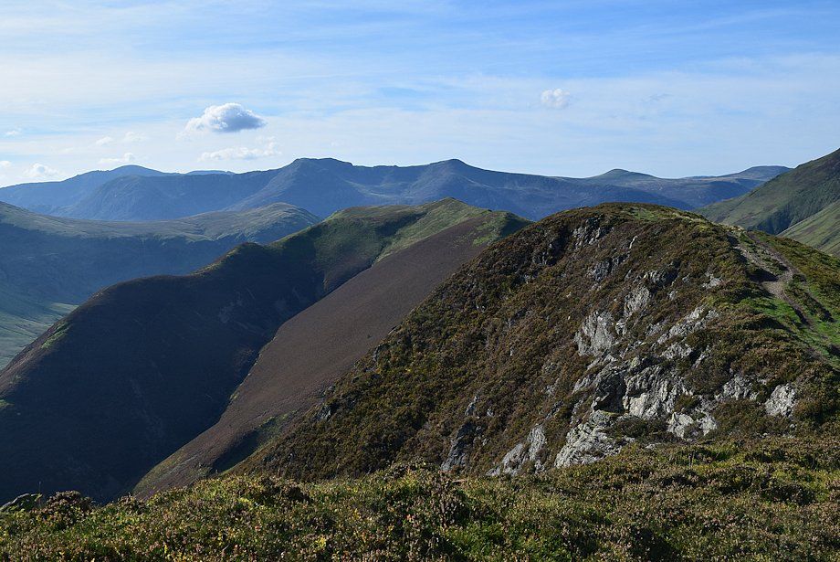
| Views to the west and north are severely restricted by the higher ridge between Wandope and Scar Grags, although Ard Crags does provide a dramatic view of the remarkable hanging valley of Addacomb Hole with the summit of Grasmoor appearing over its headwall. The best view is to the east over the lovely Newlands Valley with the full length of the Helvellyn range prominent on the horizon. A small portion of Derwent Water is visible over Ard Crags' east ridge. Looking south, the distant Scafell group is visible over the col between Hindscarth and Robinson. While to the south west the full length of High Stile ridge appears over the summit ridge leading along towards Knott Rigg. |
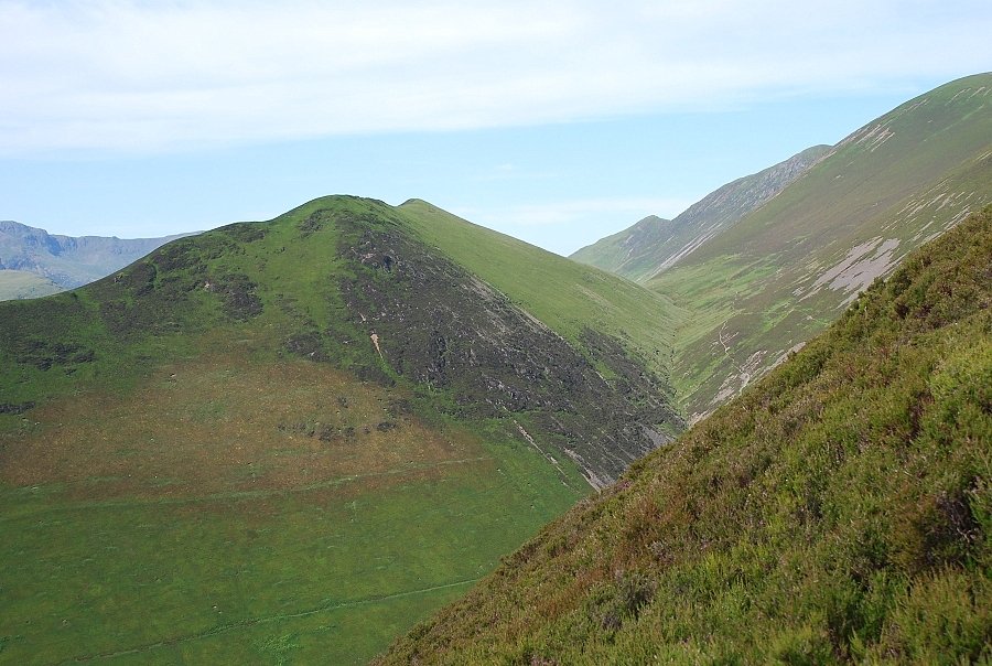
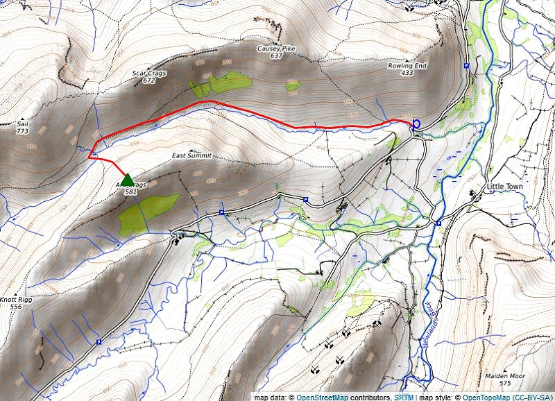
| Ridge Route to Knott Rigg |
 |
| Looking south-west to Knott Rigg (hover over image to view route map) |
|
A clear path continues through the heather along the ridge towards the Wainwright summit of Knott Rigg. Pass a notch in the crags formed by Ard Gill which gives a startling view down to Keskadale Farm. Descend to a col where the heather gives way to grass. Pass a tiny pool on the right which sometimes dries up completely in summer and climb up to the distinctive rocky knoll of Ill Crag (a Birkett top). The summit of Knott Rigg lies a little over quarter of a mile further along the almost level ridge. Distance - 0.85 mile |
|
Safe Descents All the routes of ascent described above can be safely used for descending. If returning to the Newlands Valley in bad weather, i.e. high wind, it is easier to use the more sheltered path alongside Rigg Beck. |
| Circular walks which include Ard Crags |
 |
|
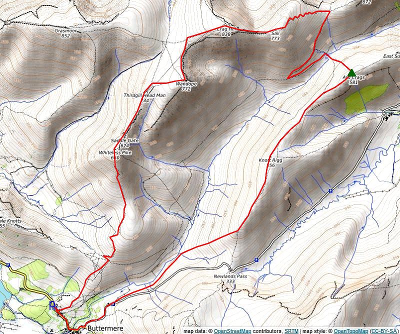
The Sail Beck Round Starting from the National Trust car park in Buttermere walk back along the road towards the village. Opposite the cottages of Crag Houses a signpost indicates the start of a path which leads over the low rise of High House Crag. On passing over the crag a wide green path climbs to a col between Low Bank and Whiteless Breast which overlooks the head of Rannerdale. The ascent continues from the col on a steep path which zig-zags up the facing slope then makes a rising traverse across the western slopes of Whiteless Breast to reach the col under Whiteless Pike and Whiteless Breast. The south ridge of Whiteless Pike steepens as the path approaches the summit, threading its way between rock outcrops, to arrive at the elegant top of Whitless Pike which gives fine views over Buttermere and Crummock Water. Descend north-east to Saddle Gate and climb the narrow ridge of Whiteless Edge, which affords dramatic views down into Third Gill on the right, to a large cairn on Third Gill Head Man. The summit of Wandope lies a third of a mile to the east across the simple grass slope of Wandope Moss. The summit cairn overlooks the hanging valley of Addacomb Hole. Leave Wandope by following the edge of Addacomb Hole as the slope steepens approaching Scar Crag veer left to join a wide path which climbs directly to the extensive summit plateau of Eel Crag. From the Ordnance Survey column marking the summit of Eel Crag head south-east to a corner of the plateau and descend the rocky east ridge (The Scar), which is steep and narrow requiring care, to the col under Sail. A good path leads up from the col to Sail's wide summit dome. The path avoids the small cairn marking the summit which lies 25 yards to the left of it beside a small pool which sometimes dries up in summer. Rejoin the path which descends the south-eastern slope of the fell to arrive at Sail Pass. Turn back sharply right at the pass and descend south-west into the valley of Sail Beck on a clear path through the heather. On joining the path which runs between Buttermere and the Newlands Valley at a prominent marker cairn turn left and climb to the high saddle between the valleys of Rigg Beck and Sail Beck. Turn right at the saddle and ascend the steep north-western flank of Ard Crags by a faint path which leads directly to the summit cairn. The summit of Knott Rigg lies 1 mile to the south-west along a delightful heather and grass ridge. The main path avoids the summit cairn wich lies to the right of it as it starts the long descent to Newlands Hause. After descending for a little over half a mile leave the path as it begins to turn slightly to the south and descend an ill-defined subsidiary ridge which leads south-west down into the valley of Sail Beck. Initially there is no trace of a path but a clear one develops amidst the bracken which covers the lower slope. Step over Swinside Gill at the foot of the ridge and follow a clear sheep trod as it climbs gently to join the Newlands Hause road a third of a mile above Buttermere village. Distance - 7.9 miles |
 |
|
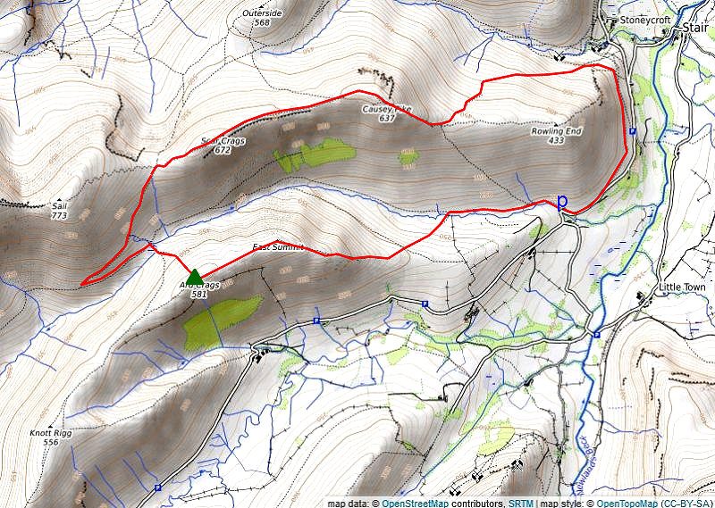
The Rigg Beck Round Park in the small disused quarry beside Rigg Beck Bridge in the Newlands Valley and walk back along the road towards Stoneycroft Bridge. On passing Rowling End Farm leave the road for a footpath which rises parallel with the road below Ellas Crag. As the path turns into the valley of Stonycroft Gill turn half left at a 'crossroads' of paths to climb steadily across the northern flank of Rowling End which offers good views of Barrow across Stonycroft Gill. Higher up the path turns more steeply to Sleet Hause below the ridge leading up to the impressive rocky dome of Causey Pike. Some mild scrambling is required to reach the summit of Causey Pike, a thin sheep trod on the left can be used to avoid the rocks. Traverse over the four cairned tops of Causey Pike and descend to the col beyond them. A simple climb along the ensuing escarpment with fine views into and across the deep trough of Rigg Beck leads easily to the large cairn on the summit of Scar Crags. Descend from Scar Crags to Sail Pass on a partly engineered path, leave the ridge at the pass and head south-west on a path which drops down towards the valley of Sail Beck. On meeting a path which runs btween Buttermere and the Newlands Valley at a marker cairn turn left and climb to the high saddle between the valleys of Sail Beck and Rigg Beck. Turn right at the saddle and climb the grassy north-western flank of Ard Crags on a steep path which leads directly to its summit cairn. Continue along the narrow ridge leading to Ard Crags' East Top, a fine viewpoint, and descend over Aikin Knott to the windening ridge above Birk Rigg. Turn half left well before the intake wall which encloses the pasture fields on a path through the bracken to cross Rigg Beck. Follow the path on the opposite bank to arrive back at the car park. Distance - 5.6 miles |
 |
|
The Greater Newlands Horseshoe Park at Chapel Bridge in the Newlands Valley and take the field path from Little town to Skelgill then the lane from there to the car park above Gutherscale. A path starts from the back of the parking area, rising diagonally to join a partly stone-pitched path which climbs steadily to the crest of Skegill Bank. Follow the gently undulating ridge leading to a final steep rise to the summit of Catbells. The upper section of the ridge requires a little scambling over bare rock to reach the top. Follow the ridge south over Mart Bield to the broad col of Hause Gate which is crossed by an old miner's path between Manesty and Little Town. Continue straight ahead from the col on a well used path which curves above Yewthwaite Combe. This main path by-passes the actual summit of Maiden Moor and, higher up, has inferior views, so when the slope eases as the path approaches the summit ridge trend right onto a lesser used path that leads up to a cairn above Maiden Moor's north-west ridge which is a wonderful viewpoint. Continue on along the escarpment, passing the head of Barnes Gill and Bull Crag to reach a small pile of stones which mark the summit of Maiden Moor. The path leads on above the edge of the steep slopes falling down to Newlands Beck on the right to rejoin the main path as it passes along Narrow Moor without gaining much height. As it begins to rise more steeply it's well worthwhile to make a small diversion to visit the cairn on Blea Crag on the left for its magnificent view of Derwent Water. Rejoin the main path as it contnues along the escarpment of Eel Crag climbing genty to the tall cairn on the summit of High Spy. Dalehead Tarn, the next objective, comes into view a few yards beyond the summit cairn. A cairned path leads down to it, passing above Miner's Crag to ford the tarn's outlet stream. Pass to the right of the tarn and embark on the 800ft. climb to the summit of Dale Head. The very steep ascent has been made easier by the construction of a stone-pitched path which leads up to an edge overlooking the northern crags, from where easier walking over grass and shale leads up to the impressive summit cairn set on the edge of the crags overlooking the Newlands Valley. The route continues westward descending to Hindscarth Edge, passing three rocky knolls on the way. Easy slopes lead up towards Hindscarth's summit ridge. Look for a shale path which branches off to the right, this provides a 'short-cut' to the summit cairn. Retrace the path south along the ridge to a junction of paths and bear rght onto a path which heads down to Littledale Edge. Traverse the narrow edge which gives good views down into Little Dale on the right and Gatesgarthdale on the left. A steady climb leads up to the summit ridge of Robinson passing above Robinson Crag and Hackney Holes to a large cairn set on the southern end of the ridge. Turn north and follow a cairned path on a gentle climb to reach the two low outcrops of rock which mark the summit of Robinson. Descend south-west on a cairned path down to the edge of Buttermere Moss. Rather than crossing the Moss directly it may be preferable to keep it on the left by circling round its edge to cross its outlet stream (Moss Beck), there is no path to follow over this section. Continue on after crossing the beck for 180 yards to join the regular path descending to Newlands Hause. A short fingerpost points the way to Ard Crags from the parking area on Newlands Hause. A broad green path sweeps up to a line of rocky outcrops on the skyline from where the summit of Knott Rigg comes into view across a slightly marshy depression. Continue on from the small cairn on Knott Rigg, passing over the subsidiary top of Ill Crag. From the depression beyond Ill Crag an attractive heather-clad ridge leads up to the summit of Ard Crags. Follow the narrow ridge towards Ard Crags' East Top which provides a fine viewpoint of the fells climbed on this circuit of the Newlands Valley. All that remains is the steep descent over Aikin Knott, as the ridge broadens below Aikin Knott trend half left onto a diagonal path through the bracken to stride over Rigg Beck. Follow the path on the opposite bank back to the road near Rigg Beck Bridge, and return along the lane opposite the bridge to the car park at Chapel Bridge Distance - 14.25 miles |
|